"GOD'S OWN COUNTRY AND GOD'S OWN AI TECHNOLOGY"
Western Ghats Mountains & the Ports of Kerala .
MOUNTAINS OF KERALA ARE THE HOST OF BIODIVERSITY & ECOSYSTEM & MOUNTAIN AIRPORTS (table top ). PORTS , ROADS , RAILWAY ARE THE THE GATE WAY OF KERALA IS DEVELOPING AI TECHNOLOGY WHICH IS THE BACKBONE OF KERALA ECONOMY IN FUTURE .
The Western Ghats are a host to God's Own Country and Kerala hosts its own AI technology in all major cities of state." is making mountains are the host of biodiversity & ecosystem with many ports,airports,railway , ferry in Kerala state in which western ghats is the backbone of Kerala state and international airports and ports are the gateways and economic lifelines that connect the state to the global economy .Artificial Intelligence (AI) is rapidly becoming integral to managing both the ecological backbone (Western Ghats) and the economic gateways (airports/ports) of Kerala. This digital transformation aims to balance rapid economic growth with environmental sustainability..
HEADLINES
Jn Data builder in Navigation route maps , Cartographer in Tourist map , GIS Engineer in Land base map
In GIS I had had 5 year experience in Surveys, Preprocessing, Digitizing, Attribution , merging , updating , geometry, layering & types balancing ,Geo reference coordinates , Geometery and Alignments in street address GPS location in Topo 1:200k , 1:250 k city maps & Aerial maps
WORKING IN GIS FOR 5 YEARS
I have been working as a digitizer of scanned maps in editor tools Lines, polygos, text & images
I had done Preprocessing of maps , Production of Digital Map of Route and Tourist maps , and Implemeting the End map with in dead end time
The Preprocessing of maps for digitization in neteditor by duplicating maps on a non luminous sheets for tracing maps on the sheets to add new roads and lines, Edited Street address updation to new address in GPS location and adding new address in raster in clavis Street address data base for route maps , Used Map derivator used to develop map layout , index of maps in outer & inner boundary area of foldimg maps and iso bars etc .
I had worked in developing route and tourist map by digitizing the scanned maps in line , text & and polygon for route and tourist map.
1. Route Map in and data India
2. Tourist map in Edgemapgis
3) Javascript, html, C C++ only a beginner
CONVERTION OF MAPS TO DIGITIAL
1) Map digitization , Map layout Making , Map Indexing
2) GIS Road Map software in Netedit for Route map Road , Boundary Network and Mapedit for Tourist map Network , Map derivator for Map layout making , and Map derivator for index page making.
3) Map digitization is the conversion of Map to digital in Roads, Rail ,Ferry,Airline , boundary , street address data base are balanced with Types and levels
4) Map layout is the outline of map area in inner and outer boundary ,bar code area , Pasting map outline text and symbols, map scales,Map all legends is merged to file
5) The Preprocessing of maps for digitization in neteditor by tracing maps on a non luminous sheets for tracing maps on the sheets to add new roads and lines, Edited Street address updation to new address in GPS location and adding new address in raster in clavis Street address data base for route maps and Map derivator used to develop map layout , index of maps in outer & inner boundary area of foldimg maps and iso bars etc
6. I had worked in the production of route maps , tourist map and land base maps of topographical maps 1:200 k , 1:250 k marcopolo and Aerial topo maps consisting of roads & boundary digitizing , layering , typing , Attributing lines , segment , nodes , point , polygon , text , features in giving accurate geometry to the map aligned to GPS location of placed
7. In the point of interest of places is similar to street address data base consisting of address , names in types and level to places on lines , segment , nodes , point , polygons in GPS location
8. Building are placed along with symbols for churches , monuments , hotels , hotels, windmill outside boundary etc
9. I had worked in attributing the segments nodes, points , polygon in road & boundary network with geocodes for tunnels , slip roads , flyovers, laybye, roundabouts , railwsy station, direction , airport and ferry routes in types and levels
10. Street address in P.O box number , firdt name , secondnames , premise in types and levels from cities to villages
11. Road sign in network for distance marker in map signs , distance between the marker or intermediate places , road elevation & inclination number , showing road altitude, and speed in different altitudes of roads as per elevation in road network and speed on road tracks
12. Digitized road network from scanned topographical & marcopolo , aerial.maps maps for single map and double line casing roads is in neteditor and mapeditor
13. Road creation is updating the road network in topographical maps with imaginary lines of types and levels for Fly over crossing slip roads like clover leaf , trumpel , junction slip roads , roundabouts with direction , by pass outer ring roads , road in construction for future in map digitizing, attribution
14. Roads are closed in bad weather giving them as sealed roads , unsealed roads peruniva and perinival roads as these roads are opened in seasons
15. Updation and enhancing works when on grid are map joins with adjacent grid area maps on four corners on continuity of roads and boundary network missing roads , geometry , types and levels , and edge mapping and outer boundary is made with Mapderivator for index pages
16. Point of interest of places is similar to street address data base done in route maps on clavis software
17. Accurate mapping can be done by using sources like Michelin, Atlas , city maps , visual and automated check
18. Road network consist of roads, railway , airline , ferry and boundary network consist of coastlines, boundary , rivers , lakes , islands , forest area polygons
19. Roads network consist of all roads from motor high way, duc roads to city roads in types and levels, motor highway flyovers crossing, laybye , roundabouts , tunnels, inter mediate places boundary roads, railway lines , railway station , crossing, etc
20. As I had digitized road network and point of interest of places in street address data base in road network point , nodes , segments , polygon , I had similar experience of work done in developing maps in Neteditor and mapeditor and Mapderivator in route and tourist map navigation ,
21. Color balancing of network is done in types and levels giving color and lines types to road network , boundary network as per the geometry and alignments inorder to balance the roads as per the categpry like major and minor highway . Color balancing is done to make flyover at T - junction and diamond junction . Color balancing is done when new roads are added to old network, color balancing is given in edge mapping as to make roads and boundary network in same color , types & levels when adjacent maps are merged
NAVIGATION MAPPING
1) and data India as junior data builder
2) Edge Map GIS as cartographer
3) GCST kochi
Work- Digitizing road and boundary network
Processing work - Digitizing , Attribution , Checking, Merging , Updating, balancing , Alignment , Geo reference coordinates navigation , Geometry,
Project - Route Maps , Tourist map , Street Address data base , Pre processing map
Map Legends - Roads , Railway , Airline , Ferry, boundaries , coastline, rivers , lakes , island , forest , symbols , city and city boundary , crossing, flyovers , by pass roads , laybye , roundabouts , tunnels, distance marker , primary and secondary names , types and levels , direction
Map scale - 1: 200 k topographical maps , 1:250 k marcopolo maps and Aerial topo maps and sources like Michelin, Atlas, city map and city inserts
Software- neteditor , Mapeditor, Mapderivator , Arc line
Tools - Lines , Segment , Nodes , Point, Text
Map type - Direction map , paper maps , folding maps , Map index , Map boundaries etc
Project - European Motor high way, European express way , European dual carriage roads , High way, city roads
Countries- Russia , Australia ,European countries - Germany , Poland, Hungary, Italy, Bolivia, Spain, ukraine Argentina ,
1999 to 2002 in and data india
2008 to 2009 in edge map
2016 in GCST
Company- (TATA Authorized Service Center) Designation - Work - CRM DMS ONLINE DATA BASE OPERATOR Work 2 _ Adobe photo shop Picture editing for advertisment Period
- JANUARY 1st 2011 TO 2012
Worked in Road data base network in Digitization , Attribution , Checks , Merging , Updating , Overlaps, Edge Mapping , the Road Network ,Boundary , River ,Town , Positioning , Geometry , Ferry Airline Data base from City map to country Maps
Resume Summary
Cartography and Navigation Jobs :
I had worked in Cartography Tourist Map development , Analysis , development , processing , printing of maps in Map digitization , Map layout Making , Map Indexing . In Cartography Map digitization consist of Layering, updation , checking and I had 5 year work experience , Map layout making 10 month experience , Map index page making .
I worked in Automated GIS Road Map software - Netedit for route map Road and Boundary Network and Mapedit for tourist map Network , Map derivator for map layout making , and Map derivator for index page making. As I had 5 year and 10 month in Digitization and Map layout making
I am submitting my resume for the cartographic job in navigation maps . Map digitization is the conversion of Map to digital by making roads, rail , ferry , Airline , boundary , street address data base in node, point, text , line symbol on type and levels in GPS position . Map layout is the outline of map area in inner and outer boundary , bar code area , Pasting map outline text and symbols, map scales , Map legends all is merged with digitized map , Index pages consisting of Heading, sub heading , in cartography job . I done aerial map updation in image file in adobe . The company I had worked is and data India as Junior data builder and edgemap gis as cartographer . Reply . I am Georgie S Cherian 49 year Male . Christian , Undergraduate with short term courses
You can view the above photos of slip roads
Application and Biodata of Georgie S Cherian with GIS Assignments
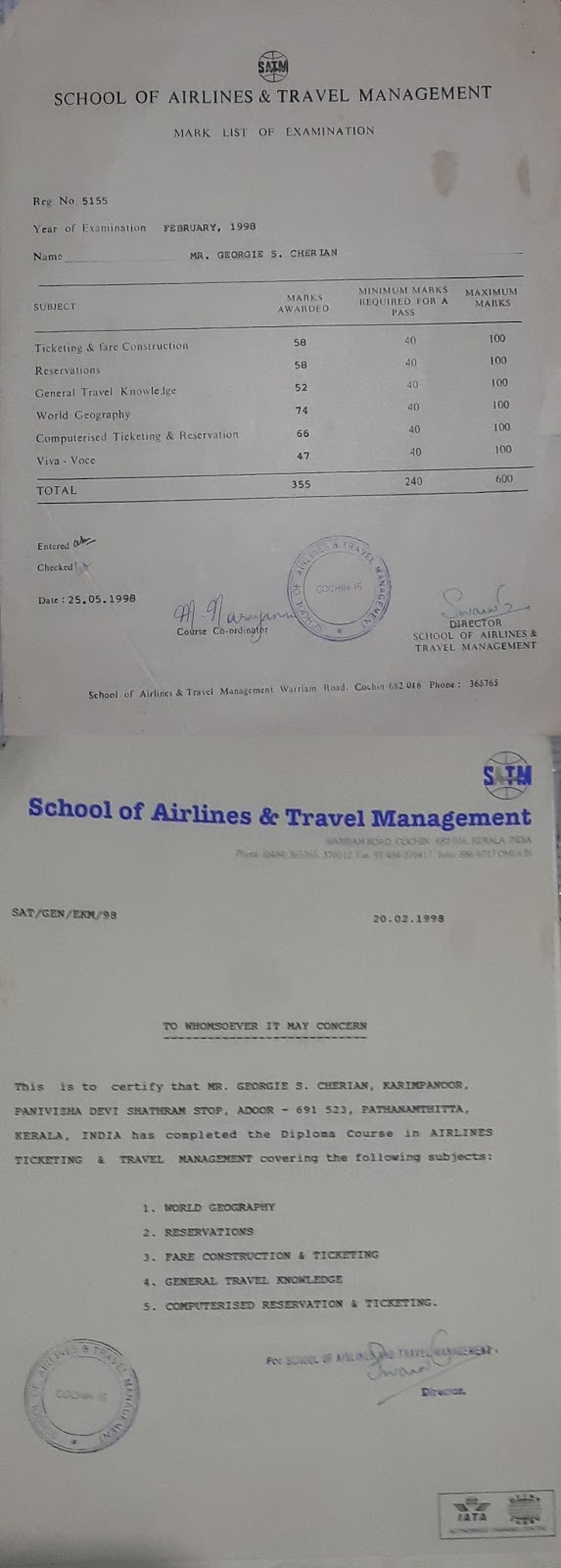
My Education is Predegree First Group ( M.G University Kerala Year 1991 ), Maths Graduation not completed (Calicut University Kerala distant education Year 1994 ) and had done Diploma computer short term course from Lakotia Computer , Cad Education training center kochi , Short term Diploma course in Marketing , Travel geography and tourism
In GIS I worked as Cartographer and Junior data Builder for a total Period of five Years and worked in developed Map on Tourisam and Route Maps . I know digitization , Attribution , Checks on Map network where the Map are digitized on Lines and segments linking one map to other to form a cluster of Grid Maps in Road Network , Boundary Network , Street Address Data Base consist of Lines, Nodes , Points , Text etc
1.From 1999 to 2002 I worked in And Data India Pune as Junior Data builder in digitzation of Route Map Data Base
website : www.and.com
At and DATA India pune year 1999 to 2002 - I completed 3 year and 4 Month from the post of the trainee in 1999 to the job of the junior data builder from August 1st 1999 to July 31st 2002 in the Production team . The software Netedit in Unix & Solaris operating system is used to develop Digital Road Network map , Digital Rail trans Network Maps, Digital Boundary Maps , Clavis Street Address Data base consisting of GPS Location of place on Name, premise, Street address, P.O Box, Province , Country , Pin code for the Route Mapping From One country of the Map to the other
EDGE MAP GIS BANGALORE
2. From 2008 January to October 17 , I worked in edgemap gis as cartographer in Tourist Maps
At EdgeMap GIS worked as Cartographer from year 2008 in the cartography project developing map and map layout in digitization , symbols, polygons, text in 1:25,000 K Map using map editor and map derivator software.
The Preprocessing of maps for digitization in neteditor by duplicating maps on a non luminous sheets for tracing maps on the sheets to add new roads and lines, Edited street address updation to new address in GPS location and adding new address in raster in clavis Street address data base for route maps in Map derivator used to develop map layout , index of maps in outer & inner boundary area of foldimg maps and iso bars etc
HYUNDAI & TATA CAR SERVICE ENATH / MAVELIKARA
3) Office job in Automobile dealer showroom & Service center - & working in online TATA Siebel 8.1 online . Adobe photo shop from 2010 to 2012.
Office job in Automobile dealership : & working online Siebel CRMDMS , Adobe Photo shop
At Tata Authorised Service from Jan 1 st 2011 to 2012 worked in editing picture for ad layout in Adobe Photo shop.
I had developed HTML Pages in html , javascript and graphics drawing in powerpoint , 3DS Max , Andriod Eclipse 3.7
3) Shobanna Gensets Pvt Ltd, cheraparambu Road , Kadavanthra, Kochi ( Franchise & Dealer of Sudheer Gensets Silvassa Mumbai & Pondicherry - for kirloskar , Ashok leyland , cummins , intac caterpillar high voltage gensets) Customer Support Executive of 5 KVA to 1000 KVA Gensets in 1996 year
4) Sale Executive for Aquarious Water Dispenser kochi ( Contract) 2015 year & done Online Ad posting
know English , Hindi ,Malayalam and Driving. I had enclosed the attached my Resume Below Along with the Application
GEORGIE S CHERIAN
MOB 07560805137
OTHER CERTIFICATE -Nano science & Technology correspondance course for three Months
OTHER CERTIFICATE -Industrial Skilled Training at CARD-Krishi Vigyan Kendra, the Farm Science Centre for Pathanamthitta District, Kerala, & Macfast center thiruvella for two week
OTHER CERTIFICATE -Industrial Skilled Training at CARD-Krishi Vigyan Kendra , thadiyoor the Farm Science Centre for Pathanamthitta District, Kerala, & Macfast center thiruvella for two week OTHER CERTIFICATE -Rubber Latex Processing training for one week OTHER CERTIFICATE - Missionary Camp at pune church for three days OTHER CERTIFICATE - Church Meeting for one day at St thomas cathedral Adoor,kerala


