
|
|
|
|
|
|


|
INDIA
|
KERALA
|
|
|
|
 |
 |
|
|
Surveys, Preprocessing, Digitizing, Attribution , merging , updating , geometry, layering & types balancing , GPS in Topo & Aerial maps 23 blogs url - GIS Mapping used in Expansion and modernising projects
Preprocessing & Digitizing Map
1) MEGA PROJECTS OF AFRICA- EAST AFRICAN
1) RAILWAYFrom Port city of Kenya to capital metropolitan city Nairobi of Kenya and extending to Uganda, ruwanda, DRC , Sudan

https://19eastafrica.blogspot.com/2019/10/mega-project-of-africa.html?m=1
2) Under ground Drone tunnel & Drainage mapping

https://19drainage.blogspot.com/2019/10/drone-scanning-drainage-leaks-blocks.html?m=1
3) Expansion & modernisation by aerial orthophoto imaging, digitizing in Aerial drone mapping
Converting of topo maps to Aerial maps by Orthophoto in which Aerial photo, satellite photo and photos are merged to develop map- REMOTE SENSING , Extracting data , & DIGITAL ORTHOPHOTO
https://aerialmsps.blogspot.com/2019/09/converting-of-topo-maps-to-aerial-maps.html?m=1
4) St Thomas Cathedral Adoor site blog.
http://www.stthomascathedraladoor.blogspot.com/
5) Mukalamplavil Family site blog
http://www.mukalamplavil.blogspot.com/
6) Holy Martyrs content writing
http://holy103.blogspot.in/2017/10/martyrs.html
7) Velankanni Basilica : Map showing the Velankani in the shore of sea

http://2017velankanni.blogspot.com/2017/07/the-road-to-velankanni.html
8) Newly designed Light House in India is a important tool in the Navigation in India : download the URl Below
Expanding & modernising coastline with light house for fishing boats, ferry boats

http://tower-light-house1.blogspot.in/2017/07/tower-light-house-in-india.html
9) Railway Navigation Data Base

http://2017railway.blogspot.in/
10) Rubber Cultivation Data Base
Expanding & modernising rubber plantatiin for large scale production
http://2017rubber.blogspot.in/
11) Tourism Data Base
http://2014keralatourisambook.blogspot.in/
Expanding & modernising tourisam by maps
12) Tourisam Data Base
Tourism : Kerala Major Rivers and River Tourist destination , Dams
http://webber11.blogspot.in/
13) Tourisam Data Base
Expanding and modernising Sabarimala with rope ways, roads. Railway
http://2014sabarimala.blogspot.in
14) Census Data Base
Census on population density with respect tp total population and expansion of places accordingly
Census : Data on 2011 Census Report and Image editing by Adobe Photoshop
http://2015indiapopulation.blogspot.in
15) Census Data Base
Population & population density in the expansion of places with new houses, roads, railway
http://2014censusdata.blogspot.in/
16) Navigation Map Data Base
Expanstion of places with sayellite SP's of roads, railway, ferry, airlines, boundary, rivers
1. G.P.S Navigation Route Mapping consisting of the Route Maps , the list of customers in European market , Project cost and revenue
http://2016navigator.blogspot.in/
17) Navigation Map Data Base
GIS Maps used for travelling from one place to other as there is expansion of roads, railway, station, ferry , airlines
http://2015gis.blogspot.in/
18) Digital Maps with New roads
Expanding Adoor town with a ring road that is connecting three highway that passes by the town to trivandrum, kochi, sabarimala, thenkqssi, kollam
http://adoor2017.blogspot.in/
19) Kochi city road and railway
Expansion of kochi city with new roads ,railways , ferry, airlines and making journey by the new roads not city roads
http://kochi11.blogspot.in/2017/05/road-and-railway-in-kochi.html
20) Sabarimala Maps : The Master Plan of Sabarimala By Maps

http://2014sabarimala.blogspot.in/
21) Developing a route map connecting the pilgrimage places in pathanamthitta district
Pilgrimage center of Pathanamthitta
http://pathanamthitta-pilgrimage.blogspot.in
22) Linked In
https://in.linkedin.com/in/georgie-s-cherian-96610758
23) CRMDMS : Customer Relation Managment and Data Base Management in B2B and B2C
http://siebel81crmdms.yolasite.com
24) Expanding & modernising hill station by rope ways
Rope Way Project connected to High way project at 12000 Crores
Chardam Rope way Project with Highway Projects
Rope Way connecting Yamunotri --- Gangotri----Man ---Badrinath --- Kedarnath-- Dasaru

25) Expanding & modernising kochi city b new route maps
Attached the car navigation and rail map outside kochi city with kochi map names
http://kochi11.blogspot.in/2017/05/road-and-railway-in-kochi.html
Preprocessing of map for digitization

Angamaly - vaikom - Cherthala railway line or road will benefit people railway and road traffic in kochi city
Car Navigation Route in cities -
Sub - Car navigation map of kochi city outer ring road Angamaly - Cherthala attached
City roads are normally occupied by bikes and cars . In cities cars and bikes are in every roads . To ensure normal flow of cars and bikes , it is necessary to make cars and bikes not stuck in traffic jam for Hrs .
Easy exit & entry to city road is by developing track on roads of car size not buses in cities . bikes & car travel in one track & buses in other track
At present city road track of bus size will make car of small size to travel in the same track of buses making a big line
As the city roads are with cars and bike , medium & heavy vehicle, it is necessary to make road tracks of the car size not the bus size
I car track bike & cars can travel and and in bus single buse, trucks and medium & heavy vehicle travelling
Sunday traffic block in cities are miserable , there is a long line of vehicle due to single track and cars , buses is stranded for hours . A 3 km long block where the police man find difficult to control the block .
This line of vehicle can be reduced if the single track road of single bus size is reduced to make car size where two cars can line up in the bus track by making track lines for cars in cities not buses
Kochi city infrastructure development is Road , Railway , Ferry , Airline
Cities like kochi there is blocks in edappally by pass junction , tripunithra is extending to long distance .
In edappally junction. The lullu hypermarket and mariot hotels itself makes lot of vehicles to the junction , and at the same time edappally perinal / festival makes block even in flyover
In tripunithra from Peta junction till ramachira or putheyakavu on other side of the town connecting tripunithra by pass the traffic block extends
People in the cities is unaware of the traffic block in the road and told from morning onwards there is traffic block
It is necessary to reduce the traffic in this roads by Developing new car navigation maps of kochi
New road route should start from Angamaly and end in Cherthala
The new car navigation route to control traffic conjunction in kochi city
1. Angamaly to cherthala outer ring roads of kochi via vykam
2. Parallel road to edappally - aroor by pass road route from edappally toll junction till tripunithra ramachira or puthiyakavu via outer ring road of tripunithara till it ends in ramachira or putiyakavu temple
3 flyover crossing crossing in edappally with no signals crossing under the bridge
4 . making roads on the side of waterways and railway in kochi city
26) Expanding Adoor town by ring road connecting high way outside the city as modernising the city
Road Mapping Adoor town :

http://adoor2017.blogspot.in/
DIGITIZED AND DEVELOPED NEW ROADS TO ADUR TOWN THAT IS CONNECTED WITH BY PASS , SH 183 MC ROAD , KP ROAD AND SH183A ROADS
Project attached a image file with colored lines road map
GRAPHICAL DRAWING OF NATIONAL HIGHWAY PROJECT IN ADUR
Adur
NATIONAL HIGHWAY PROJECT IN ADOOR TOWN IN PATHANAMTHITTA DISTRICT WITH NEW ROADS , WIDENING AND STRAIGTENING THE HIGHWAY PASSING
Widening and straightening the SH National highway Roads- Adur town is connected with three highway and the small adur town is not able to traffic from three highway passing due to geometry and limited space .the highways are
1.M C Road - SH1 Road extending from kottayam to trivandrum ----------Red Road
2. KP - SH5Road. Extending from kayamkulam to punaloor-------- Blue Road
3.SH183A - SH Road extending from kollam to dendigil going to sabarimala ------ Navy Blue Road
4 Road in Construction ------------------------------------------------------ Road In construction Yellow Road
27) Expanding & modernising Indian railway by high speed trains
Railway Navigation Data Base :

http://2017railway.blogspot.in/
Navigation map of Indian railway attached in lines types and level is done by digitizing , attribution
Connecting the railway in lines types and level -
The navigation map : railway line as per the importance on different colors line type is attached along the mail
BALANCING OF THE NETWORK FROM RED , ORANGE, BLUE , GREY , PINK , GREEN LINE AND CONNECTING IN ONE MAP
1. The red line is the corridor railway with train speed from 200 km per hr
The Corridor railway North East and North West extending from Delhi to Chennai and Delhi to Bangalore is Connecting the places : Newdelhi-----> Agra ----> Kanpur---> Lucknow----> Varnasi ----> Patna ----> Calcutta----> Bhubaneshwar ----> Vijayawada----> Chennai ----> Bangalore ----> Gundakal----> Wadi----> Pune----> Mumbai ----> Ahemdbad ----> Jaipur ----> Agra ----> New Delhi.
2. The Orange Red line or the yellow connected with red line is with train speed 150 km per hr
The Mumbai to Calcutta railway is connecting Mumbai ----> Jalgorn----> Nagpur----> Dura----> Raipur---> Rourkela----> Tata Nagar----> Calcutta and other line is Trivandrum top Jolarpetta connected to Corridor railway
3. The blue line connected to the red and orange line is with train speed 120 km pee hr
Mumbai to Kanpur from Mumbai ----> itarsi----> Jabalpur----> Katni-----> Allahabad----> Kanpur---- lucknow or Patna
4. The Black line connected the blue and orange is with train speed with 105 km per hr
Chennai to coimbatore viat Madura
5. The Dark Violet is with train speed 100 km per hr
Madurai to Kanyakumari
6. The Green line us with train speed 80 km per hr is the
other railway connected to meter guage
Line type and level for the color
Color Line type and leveling is done as per the map , old network , other sources and the entire network is balanced so that important railway geometry the railway map is developed .
1. Red line is type 1 and level 1
2. Orange Red line or the yellow line is type 2 and level 2
3. Blue line is type 3 and level 3
4. Black line is type 4 and level 4
5. Dark Violet line is type 5 and level 5
6. Green line is type 6 and level 6
The more high speed trains run in red and orange Line and fares are higher
And more passenger trains runs in green line
The. Color in map shows navigation that gives linear itinerary and feasible route and people or traveler had to change trains to go to remote places from high speed trains to low speed trains : Below the map
28) Expandimg pathanamthitta district by tourusam modernising
Pilgrimage center of Pathanamthitta and route maps

http://pathanamthitta-pilgrimage.blogspot.in
Route Map from Thiruvella and back to thiruvella
The tourist location are given below
Thiruvella and Mallapplly
SreeVallabha Temple Thiruvella
Anirudshewara temple at thiruvella
St John Metropolian cathedral thiruvella
Kizakkedath sree Subramanya temple at Mallapally
Kottangal devi temple
Paliakara church
Cherukolpuzha Convention
Thrikkaviyur Siva temple kaviyoor
Sastham kavu at Podiyadi
Ayroor
Ramaswaram Sree Mahadeva temple at Ayroor
Puthiyakavu devi temple at Ayroor
Ayroor Madam Sree Subrahmanyaswami temple
Edappavoor Devi temple at Ayroor
Kozencherry and Aranmula
Aranmula Parthasarathy at Aranmula
Elanthoor
Bhagavathikunnu devi temple at Elanthoor
Ganapathi temple At Elanthoor
Sree Dharmasastha Temple at Elantho
or Pathanamthitta
Kadammanitta Devi Temple
Sree Siva temple at Thrippara
Ranni
Malayalapuzha Devi temple
St thomas orthodox valliapally as thottamon church Ranni
Devi temple at chattamkari
Sree Mahadevar temple at perumpetty
Sabarimala
Sabarimala
Nilakkal Mahadevi Temple
Valia Koickal Sree Ayyappa temple
Vavar Shrine at Sabarimala
Nilackal Church
Vavar Shrine at Sabarimala
Pathanamthitta and Adoor
Rektha Kanda Swamy Omallur
Maramon convention
Manjinikkara church
St Mary Orthodox church
Maramon convention
Manjinikkara church
St George Orthodox church Chandanapally
Thiruvalamthuruthy Bhagavathi temple kaipattoor
Sree Padmanabha Temple at Thrikkovil
Pandalam
Valia Koickal Sree Ayyappa temple
br>
Kaipuzha Sree Krishna swamy temple
Parmala Niranam church
Parumala church
Other Places not spotted in the map
Pannayannar Kaavu parumala
Thrikkaapaaleswararam temple
Anikkattilammakshrethram
Kalloor devi temple
Mappati Bhadrakali temple
thiruverankavu devi temple
Kotunthara Sree Subramanya Temple
Sree Bhagavathi temple at Uzhuvath
Mosques
Jama Al Mosque
Pilgrimage center Maps
Distance Chart
Thiruvella to Mallapally 13.5 Km
Mallapally to Kozencherry 31 Km
Kozencherry To Pathanamthitta 13.2km
Pathanamthitta to Ranni 17.1 kmkm
Ranni to Pamba 56.8 km
Pamba to nilakal 20 km
nilakal to Pathanamthitta. 36.5 km
Pathanamthitta to Adoor 17.8 km
Adoor to Mannadi 9.8 km
Mannadi to Pandalam 9.8+11.3 k
Pandalam to Chengannur 14.4 kmkm
Chengannur to Niranam 9.5 km
Niranamto Thiruvella 11 km
Total distance = 271.7 km
Pathanamthitta Tourist Places and water falls
Gavi In Pamba
Periyar in Pamba
Konni eco tourisam
Thenmala Eco tourisam (Bordering Pathanamathitta district & Kollam district )
Thenmala water falls (Bordering Pathanamathitta district & Kollam district )
Kallada dams (Bordering Pathanamathitta district & Kollam district )
River and water ways
and water falls
I have been working as a digitizer of scanned maps with Lines, text& images . I had done Preprocessing of maps , Production of Digital Map of Route and Tourist maps , and Implemeting the End map with in dead end time
The Preprocessing of maps for digitization in neteditor by tracing maps on a non luminous sheets for tracing maps on the sheets to add new roads and lines, Edited Street address updation to new address in GPS location and adding new address in raster in clavis Street address data base for route maps , Used Map derivator used to develop map layout , index of maps in outer & inner boundary area of foldimg maps and iso bars etc
I had worked in developing route and tourist map by digitizing the scanned maps in line , text and polygon for route and tourist map.
1. Route Map in and data India 2. Toursit map in Edgemapgis
I am aware of the Javascript, html, C C++ only a beginner
www.georgiescherian.yolasite.com is the URL Link of projects
1. Map digitization , Map layout Making , Map Indexing .
2. GIS Road Map software in Netedit for Route map Road , Boundary Network and Mapedit for Tourist map Network , Map derivator for Map layout making , and Map derivator for index page making.
3. Map digitization is the conversion of Map to digital in Roads, Rail ,Ferry,Airline , boundary , street address data base are balanced with Types and levels
4. Map layout is the outline of map area in inner and outer boundary ,bar code area , Pasting map outline text and symbols, map scales,Map legends all is merged to file
The Preprocessing of maps for digitization in neteditor by tracing maps on a non luminous sheets for tracing maps on the sheets to add new roads and lines, Edited Street address updation to new address in GPS location and adding new address in raster in clavis Street address data base for route maps , Used Map derivator used to develop map layout , index of maps in outer & inner boundary area of foldimg maps and iso bars etc
| 1 Namev | Georgie.s.cherian |
| 2 Sex , Age, D.O.B | Male, 51 years , 17-08-1972 |
3 Home Addres Premise , Street Address Town, State , Country District Pin code | Georgie.s.cherian Karimpanoor House, Pannivizha East Adur, Kerala , India Pathnamthitta District 691523 |
| 4. Height & weight | 179cm 5Ft11inch & 90Kg |
| 5. India Passport | T2048243 |
| 6. Marital Status & Relegion | Married ,Christian-Jacobite |
| 7. Email | gscadoor@gmail.com |
| 8. Mobile | 7560805137 |
| 9. Landline | 04734224190 |
| Course | University | State | Year |
| 1) Predegree | Mahatma Gandhi University | Kerala |
(1991) passed |
| 2) BSc Math | Calicut University | Kerala | (1994) Incomplete |
DOS, WS, Lotus, DBASE COBOL, SAD, UNIX & C, HTML
2) 3D Max Graphics 1998 Kochi
3) ) Andriod CAD
4) ) Eclipse
12) Year of service : 5 Year IT Jobs
Designation - Work - CRM DMS ONLINE DATA BASE OPERATOR
Work 2 _ Adobe photo shop Picture editing for advertisment
Period - JANUARY 1st 2011 TO 2012
Company II and DATA India Pune (www.and.com) Designation Data Builder Road Network Topo-Road Route Map Project Work Europe , Russia , Australia ,Clavis Street address Period Year 1999 March to August 2002 1999 2000----2001 ----2002 work is digitization map
14) Language : English Hindi Malayalam
Resume Summary Cartography and Navigation Jobs : Sir , I had worked in Cartography Tourist Map development & Analysis , development , processing , printing of maps in Map digitization , Map layout Making , Map Indexing . In Cartography Map digitization consist of Layering, updation , checking and I had 5 year work experience , Map layout making 10 month experience , Map index page making nil.
I worked in Automated GIS Road Map software - Netedit for route map Road and Boundary Network and Mapedit for tourist map Network , Map derivator for map layout making , and Map derivator for index page making. As I had 5 year and 10 month in Digitization and Map layout making
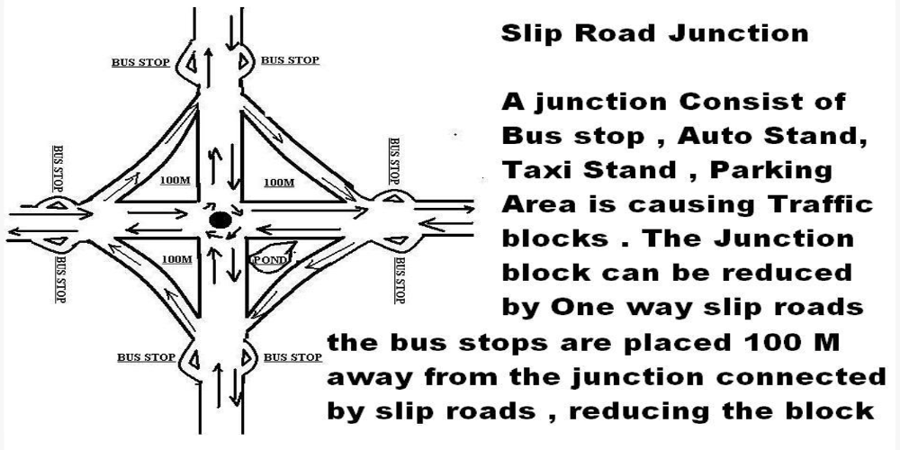
I am submitting my resume for the cartographic job in navigation maps . Map digitization is the conversion of Map to digital by making roads, rail , ferry , Airline , boundary , street address data base in node, point, text , line symbol on type and levels in GPS position . Map layout is the outline of map area in inner and outer boundary , bar code area , Pasting map outline text and symbols, map scales , Map legends all is merged with digitized map , Index pages consisting of Heading, sub heading , in cartography job . I done aerial map updation in image file in adobe . The company I had worked is and data India as Junior data builder and edgemap gis as cartographer . Pls Reply . I am Georgie S Cherian 44 year Male . Christian , Undergraduate with short term courses . You can view the above photos of slip roads
Application and Biodata of Georgie S Cherian with GIS Assignments
My Education is Predegree First Group ( M.G University Kerala Year 1991 ), Maths Graduation not completed (Calicut University Kerala distant education Year 1994 ) and had done Diploma computer short term course from Lakotia Computer , Cad Education training center kochi , Short term Diploma course in Marketing , Travel geography and tourism .
In GIS I worked as Cartographer and Junior data Builder for a total Period of five Years and worked in developed Map on Tourisam and Route Maps . I know digitization , Attribution , Checks on Map network where the Map are digitized on Lines and segments linking one map to other to form a cluster of Grid Maps in Road Network , Boundary Network , Street Address Data Base consist of Lines, Nodes , Points , Text etc
1. From 1999 to 2002 I worked in And Data India Pune as Junior Data builder in digitzation of Route Map Data Base website : www.and.com
2. From 2008 January to October 17 , I worked in edgemap gis cartographer in Tourist Maps web site : www.edgemapgis.com
3. Automobile dealer ship - TATA Siebel 8.1 online . Adobe photo shop from 2010 to 2012
At and DATA India pune year 1999 to 2002 - I completed 3 year and 4 Month from the post of the trainee in 1999 to the job of the junior data builder from August 1st 1999 to July 31st 2002 in the Production team . The software Netedit in Unix & Solaris operating system is used to develop Digital Road Network map , Digital Rail trans Network Maps, Digital
Boundary Maps , Clavis Street Address Data base consisting of GPS Location of place on Name, premise, Street address, P.OBox, Province , Country , Pin code for the Route Mapping From One country of the Map to the other
Cartogaphy Job - Previous Employer www.edgemapgis.com : At EdgeMap GIS worked as Cartographer from year 2008 in the cartography project developing map and map layout in digitization , symbols, polygons, text in 1:25,000 K Map using map editor and map derivator software
The Preprocessing of maps for digitization in neteditor by tracing maps on a non luminous sheets for tracing maps on the sheets to add new roads and lines, Edited Street address updation to new address in GPS location and adding new address in raster in clavis Street address data base for route maps , Used Map derivator used to develop map layout , index of maps in outer & inner boundary area of foldimg maps and iso bars etc
I had developed HTML Pages in html , javascript, and graphics drawing in powerpoint , 3DS Max , Andriod Eclipse 3.7
Automobile dealership : Siebel CRMDMS , Adobe Photo shop
At Tata Authorised Service center from Jan 1st , 2011 to 2012 worked in editing picture for ad layout in Adobe Photo shop
I know English , Hindi ,Malayalam and Driving
I had enclosed the attached my Resume Below Along with the Application
Age is 47 Years , Married , Christian , Physically fit
GEORGIE S CHERIAN
MOB 07560805137


No comments:
Post a Comment